


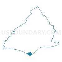
MARCUS HOOK WD 02, Delaware County, Pennsylvania
About
Outline

Summary
| Unique Area Identifier | 659251 |
| Name | MARCUS HOOK WD 02 |
| County | Delaware County |
| State | Pennsylvania |
| Area (square miles) | 1.45 |
| Land Area (square miles) | 0.94 |
| Water Area (square miles) | 0.51 |
| % of Land Area | 64.63 |
| % of Water Area | 35.37 |
| Latitude of the Internal Point | 39.81288760 |
| Longtitude of the Internal Point | -75.41620130 |
Maps

Graphs
Select a template below for downloading or customizing gragh for MARCUS HOOK WD 02, Delaware County, Pennsylvania


Neighbors
Neighoring Voting District (by Name) Neighboring Voting District on the Map
- Voting District 10-10, New Castle County, DE
- Logan township voting district 1, Gloucester County, NJ
- LOWER CHICHESTER TWP PCT 01, Delaware County, PA
- MARCUS HOOK WD 01, Delaware County, PA
- MARCUS HOOK WD 03, Delaware County, PA
- MARCUS HOOK WD 04, Delaware County, PA
- TRAINER PCT LOWER, Delaware County, PA
Top 10 Neighboring County Subdivision (by Population) Neighboring County Subdivision on the Map
- Brandywine CCD, New Castle County, DE (77,182)
- Logan township, Gloucester County, NJ (6,042)
- Lower Chichester township, Delaware County, PA (3,469)
- Marcus Hook borough, Delaware County, PA (2,397)
- Trainer borough, Delaware County, PA (1,828)
Top 10 Neighboring Place (by Population) Neighboring Place on the Map
- Claymont CDP, DE (8,253)
- Linwood CDP, PA (3,281)
- Marcus Hook borough, PA (2,397)
- Trainer borough, PA (1,828)
Top 10 Neighboring Elementary School District (by Population) Neighboring Elementary School District on the Map
Top 10 Neighboring Unified School District (by Population) Neighboring Unified School District on the Map
Top 10 Neighboring State Legislative District Lower Chamber (by Population) Neighboring State Legislative District Lower Chamber on the Map
- General Assembly District 3, NJ (235,440)
- State House District 159, PA (55,766)
- State House District 10, DE (20,187)
Top 10 Neighboring State Legislative District Upper Chamber (by Population) Neighboring State Legislative District Upper Chamber on the Map
- State Senate District 9, PA (277,401)
- State Senate District 3, NJ (235,440)
- State Senate District 5, DE (34,307)
Top 10 Neighboring 111th Congressional District (by Population) Neighboring 111th Congressional District on the Map
- Congressional District (at Large), DE (897,934)
- Congressional District 7, PA (673,623)
- Congressional District 1, NJ (669,169)
Top 10 Neighboring Census Tract (by Population) Neighboring Census Tract on the Map
- Census Tract 5024, Gloucester County, NJ (6,042)
- Census Tract 101.01, New Castle County, DE (4,573)
- Census Tract 4067, Delaware County, PA (3,469)
- Census Tract 101.04, New Castle County, DE (3,422)
- Census Tract 4066, Delaware County, PA (2,397)
- Census Tract 4065, Delaware County, PA (1,828)
- Census Tract 9901, New Castle County, DE (0)